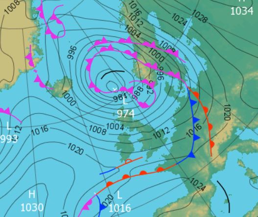
 1200 Hrs 2nd - low pressure to the north of the UK with the strongest winds on its southern flank
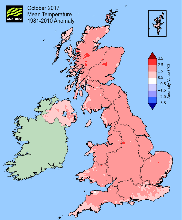
Very mild with average rainfall - daytime temperatures consistently above average.
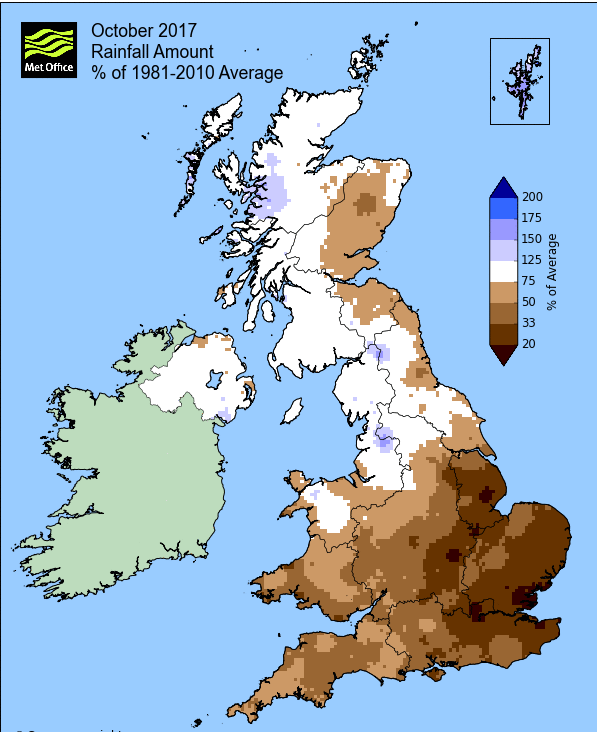
With October mainly under the influence of a warm and moist south-westerly airflow it was unsurprisingly a very mild month, particularly so by day. However, it was often cloudy and fairly uninspiring and whilst rainfall was virtually 'bang on' the average, in October that is still in excess of 100 mm (4 inches).
Those frequently high daytime temperatures peaked on the 16th with the passage of ex-tropical hurricane Ophelia which brought a brief period of gale force winds.
At the month's end a northerly airflow brought a sudden dip in temperature and with it the first air frost of the season.
In what was a generally quiet month, there was one day of fog (27th) and the one day with a gale (16th).
MSLP of 1013.1 Mb was +2.2 Mb above the local average for October and this is despite the month often being unsettled and with low pressure systems being a regular feature. High pressure from the 25th through to the month's end brought the quietest spell of weather during the month and which caused the 'bar' to finish above average.
Overall a mean minimum of 7.79°c and a mean maximum of 14.15°c saw the temperature 1.9°c above the 1981-2010 average. It was the warmest since 2013 and of the nine now recorded, 6 have been colder and 1 warmer. The highest maximum temperature recorded was 18.9°c (16th), the lowest minimum -2.4°c (30th).
Rainfall of 111.7 mm (Crosby Ravensworth School 135.4 mm - Castlehowe Scar 166.4 mm - Reagill 109.7 mm) was 97.5% of average for 2007-16 and made it the wettest October since 2014. Of the 11 now recorded 5 have been drier and 5 have been wetter.
Locally, rainfall percentages were generally very close to average, but within the Lake District they rose well above normal, reaching 176.7% at Seathwaite Farm. Seathwaite was excessively wet during the five days of 9-13th, totalling 284.6 mm, with 119.4 mm of that falling on the 9th.
At the Met' Office site at Newton Rigg, 80.2 mm (75%) made it the wettest October since 2014 and in a series back to 1900, October has been drier in 42 years and wetter in 74 years (1yr of missing data). A mean temperature of 10.75°c is the warmest since 2013 and in a series back to 1951, 54 have been colder and 12 have been warmer.
Figures from the Environment Agency’s rainfall sites were, (figure in brackets being the monthly average for 1961-90) ‘Data kindly provided by the Hydrometry and Telemetry team of the Environment Agency (Penrith)’:
Kirkby Thore 68.2 mm (65.8 mm)
Haresceugh Castle (Kirkoswald) 88.1 mm (101.0 mm)
Brothers Water 398.33 mm (276 mm) and
687.4 mm at Seathwaite Farm (Borrowdale - 389 mm [average for 1981-2010])
1st - 8th Somewhat mixed at the start of the month, generally under the influence of a W'ly flow and with low and high pressure systems interchanging - breezy, showery, brighter during the end of the period and rainfall was relatively light.
Low Pressure (LP) was in charge at first, building and deepening in the Atlantic, but tracking north of the UK. Whilst the 1st was a dreary day, the 2nd was cloudy and blustery.
1200 Hrs 2nd - low pressure to the north of the UK with the strongest winds on its southern flank
With high pressure (HP) to the SW, the 3rd was a quiet day before the 4th saw patchy light rain, heavier in the evening as a cold front moved north-south. Behind this front the 5-6th saw some sunshine as the HP in Biscay tried to assert itself over the UK and under clearer skies the 6th started with a ground frost.
Fronts would tend to be over or near the UK for the rest of the period, but apart from overcast skies and some drizzle on the 7th, it was all fairly quiet.
9th - 17th A series of LP systems brought milder, unsettled and wet conditions, culminating in the arrival of Ophelia on the 16th.
High pressure over the continent tended to push the those LP systems to our north, but the resulting SW'ly flow saw day-time temperatures typically in the range of 14-16°c and night-time minima staying above 10°c - this was also the wettest period of the month.
Whilst the 10th had been a reasonable day, rain overnight into the 11th saw 14.4 mm (credited back to the 10th) with the 11th seeing a further 11.0 mm as the day stayed wet. Generally cloudy on the 12th, but more rain overnight into the 13th saw 10.9 mm (credited back to the 12th) and the day itself was grey and drizzly (4.9 mm).
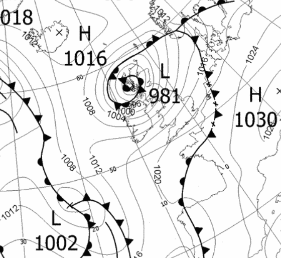
The next few days were all grey and overcast with some rain and then Ophelia arrived. The 16th started quite calm and it wasn't until the evening that the winds really started to get blowing. The wind peaked between 1030 and 1130 p.m. with a sustained 10 minute average of 39 mph attained just before 11 p.m. and just enough to be classed as a 'gale'.
The rainfall that accompanied Ophelia was not especially heavy, just 8.0 mm and which was also at its heaviest during the strongest winds.
Ophelia with its warm air and southerly flow was also responsible for bringing us the month's highest temperature of 18.9°c (66°f). Curiously though and despite its proximity to the UK, air pressure never fell below 1000Mb.

18th - 24th High pressure tried but never managed to establish itself on the 18th, although the day was dry with sunny spells, but LP systems to our south and west would converge on the UK during the latter part of the 19th. The rain arrived at 1500 hrs and continued through to the next morning, giving 24.6 mm of rain and the month's wettest day.
It remained unsettled and on the 21st Storm Brian arrived from the SW and tracked north, passing directly over Cumbria. Whilst the pressure fell to 982.1 MB the strongest winds were felt on the southern flank of the storm and hence in Cumbria it was nothing more than a wet afternoon and evening (8.5 mm).
The unsettled theme still had a few days to go, lasting through to the early hours of the 25th as more fronts maintained a mild and overcast few days, the 24th seeing a high temperature of 16.4°c.
25th - 31st Whilst rarely fully established over the UK, high pressure gradually became the more dominant feature and with clearer skies we finally got to see some sunshine and cooler nights.
Initially the HP was over the continent, migrated west before weakening briefly. It then became established over the UK only to migrate south, then west, giving at first a brisk W'ly over its top, followed by a cool N'ly.
In all it was a reasonable end to the month with sunshine prominent during the 25-29th. During the period, the 27th started foggy, but this had lifted to sun by 1015 hrs and then the 29th felt quite raw with a strong N'ly flow and was the first day of the season to remain below 10°c - 9.6°c (49.3°f) being a month's low.
With the HP moving in from the west and becoming established over the UK overnight into the 30th, the skies cleared and the temperature tumbled to a month's low of -2.4°c (27.7°f).
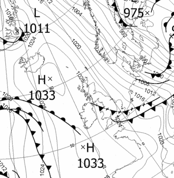 1200 Hrs 29th - high pressure in the Atlantic drawing down the cooler N'ly flow.
Rainfall totalled 111.7 mm for the month, with rain recorded on 18 days of which 14 were 'Wet days' (1.0mm +).
The Mean Temperature for the month was 10.97°c -- The Mean Max' was 14.15°c -- The Mean Min' 7.798°c.
We had 2 Air Frosts in the month (year 34) -- Grass frosts totalled 5 (year 73).
The 1 foot soil temp ranged from a low of 9.7°c on the 31st to a high of 13.1°c on the 15th -- with a monthly mean of 12.1°c
The 1 meter soil temp ranged from a low of 11.5°c on the 30th-31st to a high of 13.0°c on the 1st -- with a monthly mean of 12.2°c
COMPARISONS:-
* October 2017 rainfall was 97.5% of the average for 2007 - 2016
* October 2017 was 1.33°c warmer than the average for 2009 - 2016 and 1.9°c warmer than the local long term average 1981-2010
* This makes the Jan' to October period of 2017 some 0.70°c warmer than the average for 2009-16 and with 99.4% of average rainfall for 2008-16
JANUARY 2010
FEBRUARY 2010
MARCH 2010
APRIL 2010
MAY 2010
JUNE 2010
JULY 2010
AUGUST 2010
SEPTEMBER 2010
OCTOBER 2010
NOVEMBER 2010
DECEMBER 2010
JANUARY 2011
FEBRUARY 2011
MARCH 2011
APRIL 2011
MAY 2011
JUNE 2011
JULY 2011
AUGUST 2011
SEPTEMBER 2011
OCTOBER 2011
NOVEMBER 2011
DECEMBER 2011
JANUARY 2012
FEBRUARY 2012
MARCH 2012
APRIL 2012
MAY 2012
JUNE 2012
JULY 2012
AUGUST 2012
SEPTEMBER 2012
OCTOBER 2012
NOVEMBER 2012
DECEMBER 2012
SUMMER 2012
REVIEW OF 2012
JANUARY 2013
FEBRUARY 2013
MARCH 2013
APRIL 2013
MAY 2013
JUNE 2013
JULY 2013
AUGUST 2013
SEPTEMBER 2013
OCTOBER 2013
NOVEMBER 2013
DECEMBER 2013
REVIEW OF 2013
JANUARY 2014
FEBRUARY 2014
MARCH 2014
APRIL 2014
MAY 2014
JUNE 2014
JULY 2014
AUGUST 2014
SEPTEMBER 2014
OCTOBER 2014
NOVEMBER 2014
DECEMBER 2014
WINTER 2014
REVIEW OF 2014
JANUARY 2015
FEBRUARY 2015
MARCH 2015
APRIL 2015
MAY 2015
JUNE 2015
JULY 2015
AUGUST 2015
SEPTEMBER 2015
OCTOBER 2015
NOVEMBER 2015
DECEMBER 2015
REVIEW OF 2015
JANUARY 2016
FEBRUARY 2016
MARCH 2016
APRIL 2016
MAY 2016
JUNE 2016
JULY 2016
AUGUST 2016
SEPTEMBER 2016
OCTOBER 2016
NOVEMBER 2016
DECEMBER 2016
REVIEW OF 2016
JANUARY 2017
FEBRUARY 2017
MARCH 2017
APRIL 2017
MAY 2017
JUNE 2017
JULY 2017
AUGUST 2017
SEPTEMBER 2017
OTHER ARTICLES
The Oldest Inhabitant
An Inch Of Scotch Mist
© Darren Rogers 2010-17
Want to comment on this site? email